
THE last time I commented on the 2026/27 El Niño phenomenon was two months ago (https://utusansarawak.com.my/a-strong-el-nino-is-forecast-to-return-by-mid-2026/), when climate model forecasts at the time suggested that El Niño was expected to begin around June 2026 with a probability of about 60 percent, and continue through to the end of the year and early 2027 with a probability of around 80 percent.
Now, we are on the verge of the onset of the 2026/27 El Niño, and this article aims to provide an update on the latest developments while sharing an overview of the weather and climate conditions expected to affect Malaysia and the wider region during this El Niño episode.
The latest update issued by NOAA through its Climate Prediction Center on 18 May 2026 indicates that this phenomenon is now almost certain to occur.
The probability of El Niño developing during the Southwest Monsoon season, namely in June, July and August, has now risen to above 80 percent compared with around 60 percent in earlier forecasts.
For the period extending towards the end of the year, the probability is now approaching 100 percent, meaning the event is considered almost certain. In its latest outlook, the centre has also maintained the status as “El Niño Watch”.
Forecasts issued by the APEC Climate Center (APCC) in Busan, South Korea on 15 May 2026 placed the status at “El Niño” for the period from June to November 2026.
Meanwhile, various models under the European Centre for Medium-Range Weather Forecasts and Copernicus Climate Change Service indicate that nearly 100 percent of their models project El Niño conditions to develop from this June and persist through the end of the year and into early next year.
Recent observations released by the United States Climate Prediction Center also show that warming of sea surface temperatures in the central and eastern Pacific Ocean has already begun.
At this stage, the main question is no longer whether El Niño will occur, but rather how strong it will become.
Since my previous article on El Niño two months ago, many international media reports have used the term “super El Niño”. However, I remain somewhat cautious about using the term because there is no specific scientific definition for it.
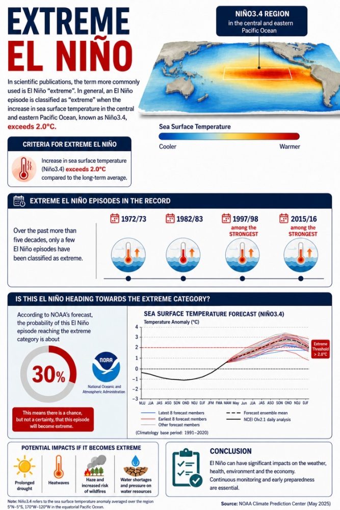
In scientific publications, the more commonly used term is “extreme” El Niño. Generally, an El Niño episode is categorised as “extreme” when sea surface temperature anomalies in the central and eastern Pacific Ocean region, known as Niño3.4, exceed 2.0°C.
Over the past five decades, only a few El Niño episodes have fallen into this category, including the events of 1972/73, 1982/83, 1997/98 and 2015/16.
Among these, the 1997/98 and 2015/16 events are regarded as the strongest in the modern observational record.
Is this El Niño now heading towards the extreme category? According to forecasts from NOAA, the probability of this event reaching extreme status is around 30 percent.
However, forecasts from the APCC in Busan place the probability at above 90 percent. Models under the European Centre for Medium-Range Weather Forecasts and Copernicus Climate Change Service also show that more than 50 percent of their models project an extreme El Niño event.
Based on my expertise and observations of current developments, I believe that this El Niño has the potential to evolve into an event comparable to the 1997/98 and 2015/16 El Niño episodes, namely one within the extreme category.
This assessment is supported by the latest data on thermocline depth changes in the Pacific Ocean, which are now displaying patterns remarkably similar to those observed during the early development stages of the 1997/98 and 2015/16 El Niño events.
I would like to issue a warning regarding the potential disasters often associated with extreme El Niño events. Prolonged droughts, heatwaves, and increased risks of forest and vegetation fires both locally and in neighbouring countries could trigger episodes of local and transboundary haze.
We are also expected to face impacts on water resources, declining agricultural yields, and adverse effects on public health.
The question is: are we truly prepared? Are we giving the same level of attention to the threat of an extreme El Niño as we do to the impacts of the monsoon season?
If we and the relevant authorities are still unprepared, I would urge that adaptation and preparedness measures be implemented immediately in order to minimise the impacts of the 2026/27 El Niño, which has the potential to rival the strength of the 1997/98 and 2015/16 events.
Professor Emeritus Dr Fredolin Tangang is an Emeritus Professor in climatology and climate change at Universiti Kebangsaan Malaysia, a Fellow of the Academy of Sciences Malaysia, and is currently serving at Universiti Brunei Darussalam. He is a former Vice-Chair of Working Group I of the Intergovernmental Panel on Climate Change under the United Nations.